A map is a two-dimensional representation of the Earth’s surface, providing detailed information about regions, landmarks, and political boundaries, but it distorts the actual sizes and shapes of landmasses. On the other hand, a globe is a three-dimensional model of the Earth, offering a more accurate depiction of its shapes, sizes, and spatial relationships, making it ideal for understanding global geography and navigation.
Key Takeaways
- Maps and globes are tools used to represent the Earth’s surface. Maps are two-dimensional representations of the Earth’s surface, while globes are three-dimensional representations of the Earth.
- Maps provide detailed information on specific areas of the Earth, while globes accurately represent the Earth as a whole.
- Maps are more convenient and easier for daily navigation and planning, while globes are better suited for understanding the Earth’s geography and spatial relationships between regions.
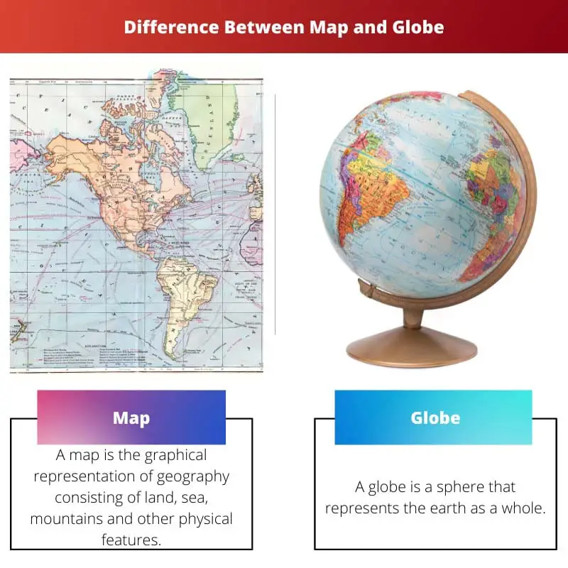
Map vs Globe
A map is a two-dimensional representation of the Earth’s surface; it is flat, shows a specific area, and can be easily carried around, making it a popular tool for navigation. A globe is a three-dimensional representation of the Earth; they are more accurate regarding land and ocean proportions.

Comparison Table
| Feature | Map | Globe |
|---|---|---|
| Dimensionality | Two-dimensional (2D) | Three-dimensional (3D) |
| Representation | Flat surface showing a specific area or the entire Earth | Spherical model of the Earth |
| Accuracy of scale and distance | Can distort distances and areas, especially near the edges of flat maps | Shows accurate relative sizes and distances between locations |
| Detail | Can show a high level of detail for a specific area | Shows a general overview of the Earth with less detail |
| Portability | Easy to fold and carry | Large and stationary |
| Usefulness for navigation | Useful for detailed navigation within a specific area | Useful for understanding global relationships and distances |
| Cost | Generally less expensive | Generally more expensive |
What is a Map?
A map is a graphical representation of a geographical area, showing the Earth’s surface or a portion of it. Maps serve various purposes, including navigation, education, planning, and analysis. They provide valuable spatial information that helps individuals, businesses, governments, and researchers understand the world around them.
Components of a Map
- Title: The title of a map describes the area it represents or the specific theme it addresses. It provides essential context to the reader about the purpose or focus of the map.
- Legend or Key: A legend or key explains the symbols, colors, and other visual elements used on the map. It helps users interpret the map’s information, such as differentiating between landmarks, terrain types, or administrative boundaries.
- Scale: The scale of a map indicates the relationship between distances on the map and corresponding distances on the Earth’s surface. It enables users to gauge the size of features and distances portrayed on the map accurately.
- Symbols and Icons: Maps use symbols and icons to represent various features such as cities, roads, rivers, mountains, and landmarks. These graphical elements simplify complex geographic information, making it easier to understand and interpret.
- Gridlines and Coordinates: Gridlines and coordinates provide a framework for locating specific points on the map. They divide the map into manageable sections and allow for precise navigation and referencing.
Types of Maps
- Political Maps: Political maps display governmental boundaries, such as countries, states, and cities. They emphasize political features like capitals, borders, and territorial divisions.
- Physical Maps: Physical maps depict natural features of the Earth’s surface, such as mountains, rivers, forests, and deserts. They provide insights into the topography and geological characteristics of an area.
- Thematic Maps: Thematic maps focus on specific themes or subjects, such as population density, climate patterns, economic activities, or cultural distributions. They use various visual techniques to illustrate spatial patterns and relationships related to the chosen theme.
- Topographic Maps: Topographic maps represent the elevation and terrain features of a geographic area using contour lines and shading. They are useful for outdoor enthusiasts, urban planners, and engineers for understanding landforms and planning infrastructure.
Importance of Maps
Maps play a crucial role in our understanding of the world and its diverse landscapes. They facilitate navigation, spatial analysis, decision-making, and communication across various disciplines and industries. From planning travel routes to studying environmental patterns, maps provide invaluable tools for exploration, research, and education.

What is a Globe?
A globe is a three-dimensional representation of the Earth, accurately depicting its shape, size, and spatial relationships. Unlike flat maps, globes provide a more realistic portrayal of the Earth’s surface, allowing viewers to observe its spherical nature and understand geographical features in their proper context.
Construction of a Globe
- Sphere: The main body of the globe is a spherical framework, made of hollow or solid materials. This spherical shape accurately reflects the Earth’s curvature, ensuring that distances, sizes, and shapes are represented proportionally.
- Map Projection: The surface of the globe features a map projection, which is a method used to transfer the Earth’s curved surface onto a two-dimensional medium. Common map projections used on globes include Mercator, Robinson, and Winkel Tripel projections, each offering advantages in preserving different aspects of geographic accuracy.
- Geographical Features: Globes display various geographical features such as continents, countries, oceans, mountains, and rivers. These features are depicted with appropriate colors, labels, and shading to enhance clarity and visual appeal.
- Axis and Stand: A globe rests on an axis, allowing it to rotate freely. The axis is tilted at an angle to simulate the Earth’s axial tilt, facilitating a better understanding of concepts such as the seasons and the distribution of sunlight. The globe may be mounted on a stand, providing stability and allowing users to easily rotate and examine different regions.
Uses of Globes
- Geographic Education: Globes are invaluable tools for teaching geography, providing students with a tactile and visual representation of the Earth. They help learners understand concepts such as latitude, longitude, hemispheres, and the spherical nature of the planet.
- Spatial Visualization: Globes aid in spatial visualization, allowing users to grasp the relative positions of continents, countries, and oceans more intuitively than flat maps. They provide a holistic view of the Earth, facilitating better comprehension of global patterns and relationships.
- Navigation and Orientation: Globes assist navigators, explorers, and aviators in understanding routes, distances, and directions across the Earth’s surface. By rotating the globe and observing the relationship between different regions, users can plan journeys, analyze geographical obstacles, and navigate with greater precision.
- Decorative and Cultural Significance: Globes are used as decorative items in homes, offices, and educational institutions. They symbolize exploration, curiosity, and the interconnectedness of the world’s diverse cultures and environments.

Main Differences Between Map and Globe
- Dimensionality:
- A map is a two-dimensional representation of the Earth’s surface.
- A globe is a three-dimensional model of the Earth, accurately depicting its spherical shape.
- Accuracy and Distortion:
- Maps can suffer from distortion, particularly in terms of size and shape of landmasses, due to the challenge of representing a curved surface on a flat plane.
- Globes offer greater accuracy as they maintain the true shapes, sizes, and spatial relationships of geographic features, providing a more realistic depiction of the Earth.
- Portability and Practicality:
- Maps are more portable and convenient for everyday use, as they can be easily folded, stored, and transported.
- Globes are less portable due to their bulkiness and require space for display, making them less practical for on-the-go navigation but more suitable for educational purposes and decorative use.
- https://link.springer.com/content/pdf/10.1007/s00122-006-0256-8.pdf
- https://www.tandfonline.com/doi/pdf/10.1080/00221348108980689
- https://eric.ed.gov/?id=ED255416
Last Updated : 02 March, 2024

Piyush Yadav has spent the past 25 years working as a physicist in the local community. He is a physicist passionate about making science more accessible to our readers. He holds a BSc in Natural Sciences and Post Graduate Diploma in Environmental Science. You can read more about him on his bio page.


The elucidation of the key differences between maps and globes is not only enlightening but also intellectually stimulating.
Indeed, the article effectively challenges readers to engage critically with the topic.
This article provides a thorough and meticulous comparison between the functionalities of maps and globes, which is greatly appreciated.
I couldn’t agree more, the attention to detail in describing the main differences is truly commendable.
The article effectively communicates the significance of maps and globes as tools of geographic representation.
The author presents the comparison between maps and globes in a clear and logical manner, making it easy to comprehend.
Absolutely, the clarity of the presentation makes it accessible to readers with varying levels of familiarity with the topic.
I appreciate the in-depth analysis of maps and globes in this article, very informative and helpful.
Yes, I’ve gained a better understanding of how maps and globes function as tools of representation.
It’s fascinating to learn about the Latin origin of the word ‘globe’, adding an interesting historical context to the discussion about globes.
The comprehensive explanation of the main differences between maps and globes was quite enlightening.
I found that part intriguing as well, it’s always great to know the historical evolution of such important tools.
The historical insights into the invention and evolution of globes are both engaging and educational.
I found the historical context quite captivating as well, adds an extra layer of appreciation for these tools.
This article provides an insightful comparison between maps and globes, outlining the key differences comprehensively.
I agree, the detailed explanation of how maps and globes differ is very informative.
I appreciate how the article delves into the history of map-making and globe construction.
This piece does a wonderful job of elucidating the fundamental aspects associated with maps and globes, insightful and thought-provoking.
The article’s detailed analysis and comparison of maps and globes is a testament to the author’s expertise and comprehensive understanding of the subject matter.
The informative nature of the article is truly commendable, providing a wealth of knowledge about maps and globes.
It’s evident that the author has a deep knowledge of the field, making this a highly valuable read.
The in-depth analysis and comparison of maps and globes is a valuable contribution to the discourse on geography and cartography.