A map is, in simple terms, a representation of a place. It is the diagrammatic representation of physical features, districts, cities, roads, and other essential features of an area of land or sea. The two main types of maps are political and physical maps.
Key Takeaways
- Political maps show boundaries between countries, states, or territories, while physical maps show geographical features like mountains, rivers, and oceans.
- Political maps help to understand an area’s administrative and political divisions, while physical maps help to visualize the topography of an area.
- Both maps provide different information and can be used for different purposes.
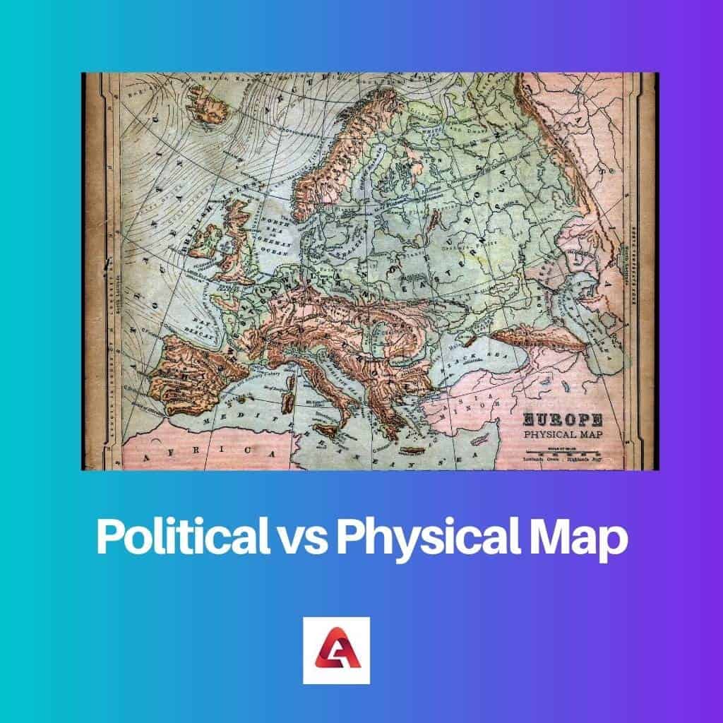
Political vs Physical Map
The difference between political and physical maps is that political maps focus on the boundaries between states, countries, districts, etc., while physical maps focus on the geography of the area.
Political maps are in bright colors to distinguish the boundaries between various states and countries. It is commonly used by tourists and other people for navigation or to gain knowledge about the area. These maps make use of large water bodies like oceans, seas, rivers, etc., as landmarks.
Physical maps aim to show the geography of the area represented. They have shaded relief to show physical features like valleys, mountains, and other elevations. It follows a green to brown to a gray color scheme for show elevation for land and shades of blue for water bodies.
Comparison Table
| Parameters of Comparison | Political Map | Physical Map |
|---|---|---|
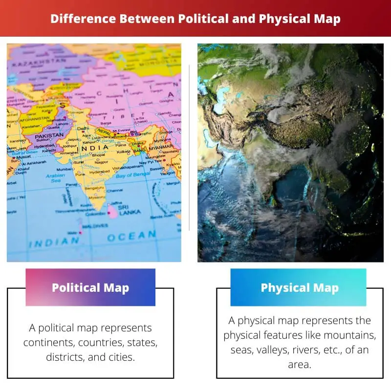
| Meaning | A political map represents continents, countries, states, districts, and cities. | A political map represents the physical features like mountains, seas, valleys, rivers, etc., of an area. |
| Representation | It shows territorial boundaries and the names of a particular area. | It shows the geography of the area and has shaded relief to show elevations. |
| Colour Scheme | It consists of bright colors to distinguish clearly between countries and states. | The land follows a green to brown to a grey color scheme; shades of blue are used for water bodies and white for glaciers. |
| Features | It is flat and two-dimensional. | It has shaded and dipped relief. It is three-dimensional. |
| Practical Applications | Political Maps are used to show the geography of countries. It is also widely used in schools. | Pilots use this map for safe flying. Students use this map for the research of a particular area. |
What is Political Map?
While physical maps show the geography of a particular region, political maps concentrate on the names and political boundaries concerning it. They are widely used as reference maps everywhere, from schools to police stations, and used by many people, from the government to travellers.
It shows government and geographic boundaries between countries, states, districts, cities, etc. Political maps deal with the indication of the politics of an area, including political boundaries. It represents the political divisions, the man-made boundaries existing between continents, countries, etc.
Political maps also feature different colors, like physical maps. A political map features a different set of colors within a map to show states, districts, provinces, etc.
But, it consists of bright colors to distinguish clearly between different countries, states, provinces, and regions. However, there is no rule for choosing colors, and the selection is arbitrary.
Political maps do not feature topographical features, but they can indicate physical features like drainage elements like lakes, rivers, etc.
It can also contain the capital of different places and transportation networks like roads and rail. Sometimes, a political boundary can coincide with a geographical boundary like rivers, seas, and mountains.
What is Physical Map?
Physical maps are mainly made to study the geography of an area. It shows the various physical features of a region. It may contain some boundaries, but this isn’t the main focus. It can also contain some names indicating the places in the represented area.
In a physical map, different colors are used to depict various physical features. It follows a green to brown to a gray color scheme for showing land features. For water bodies, shades of blue are used, and white is used for glaciers and ice caps.
The color dark green is used to represent near-sea-elevations, and it gradually varies to browns as the elevation increases. The color grey is used for the highest point of elevation.
Rivers, lakes, seas, oceans, and gulfs appear in shades of blue, with light blue for shallow ends that graduate to darker blues as the depth increases. Streams and rivers are represented by thin blue lines.
Like all the other maps, physical maps also mention a key that can be used to understand all the symbols represented in the map. Since these maps are made to show the earth’s geography and natural landscape, they can be used by almost anyone who requires information in this area.
Pilots use this map to know about the landscape to fly at a higher elevation to avoid crashing into physical features like mountains. Students use this map to research any geographical feature or area.
Main Differences Between Political and Physical Map
- A political map represents countries, states, etc. A physical map represents the geography of a particular area.
- Political maps show territorial boundaries and names. Physical maps show the physical features of the represented region.
- Political maps are in bright colors to clearly distinguish between the boundaries. Physical maps follow a predetermined set of color schemes for different physical features.
- Political maps are flat but physical maps have shaded relief. A political map is two-dimensional, while a physical map is three-dimensional.
- Political maps are used in schools and are used to show the geographies of countries. Physical maps are used by pilots for safe flying and by students for research of a particular area.

The detailed descriptions and the comparison table in this article make it an excellent resource for learning about political and physical maps.
I found this article to be quite comprehensive, offering valuable insights into political and physical maps.
I couldn’t agree more. The clarity in the explanations helps in understanding the realms of different maps.
The details about the use of colors and the key takeaways from this article are great. It’s a valuable resource for understanding maps.
I appreciate the depth of information provided here. It’s a rich source for understanding the details of different map types.
Absolutely! The breakdown of political versus physical maps is presented in a way that’s easy to comprehend.
The material presented in this article is very educational and brings greater clarity to the distinctions between political and physical maps.
The explanations about political and physical maps’ features are thorough and insightful. This content is a great learning tool.
Absolutely! The depth of information provided here makes it a valuable learning resource for anyone interested in understanding maps.
This article effectively explains the essentials of political and physical maps. The detailed descriptions are beneficial, especially for educational purposes.
Agreed. The article provides a well-structured breakdown of political and physical maps, which is highly beneficial for learning and reference.
Absolutely! The clarity in this content makes it an excellent resource for understanding these map types.
The comparison table in this article is quite helpful in understanding the distinctions between political and physical maps. I’m glad to have come across this detailed content.
I appreciate how the article emphasizes the practical applications of both political and physical maps, making it very useful for various purposes.
I agree! The table makes it easy to see the significant differences between political and physical maps.
The distinctions between political and physical maps are well articulated in this post. It’s a great source of knowledge for anyone wanting to understand the nature of different maps.
I couldn’t agree more. The explanations about color representations in physical maps are quite enlightening.
I found the information about the color schemes in physical maps to be particularly interesting. This article is indeed very informative.
I appreciate the comprehensive breakdown of political maps and physical maps in this article. The comparative analysis is very enlightening.
Absolutely! The details provided here are very informative and helpful in understanding the nuances of different map types.
The practical applications of political maps highlighted in this article are quite enlightening. It provides a holistic view of the purpose of these maps.
I completely agree. The article effectively discusses the real-world applications of political maps.
Thank you for this insightful article about maps! I appreciate the detailed comparison between political and physical maps, as well as the comprehensive explanation of what each type entails.
I found this article to be very informative. It gives a clear explanation of the differences and uses of political and physical maps.
Absolutely! This post provides great information that helps us understand the purpose and features of political and physical maps.